GPS Published Approach Runway 31.
See Canada Air Pilot for particulars.
Pilots who wish to land at the Quesnel Airport should take note of the following Airport coordinates and flight data:
Information subject to change, refer to the latest Canada Flight Supplement to ensure correct information.
Last Update: December 15, 2011
REF: N53 01 34 W122 30 37 2N 20ºE UTC-8(7) Elev 1788’ A5014 LO2 H13 CAP
OPR: City 250-992-2208 Cert
PF: A-1,6 C-2,3,4,5
Flt Pln
NOTAM FILE CYQZ
FIC: Kamloops 1-866-WXBRIEF (toll free within Canada) or 1-866-541-4101 (toll free within Canada and USA)/Pilot Flight Planning Room located Operations Building, just north of main terminal, 24-hour access.
WX: AWOS (see COMM) Rdo. 124.4 WX CAMERAS.
TAF 12-06Z, issue times: 12, 19, 01Z.
FREE WIFI.
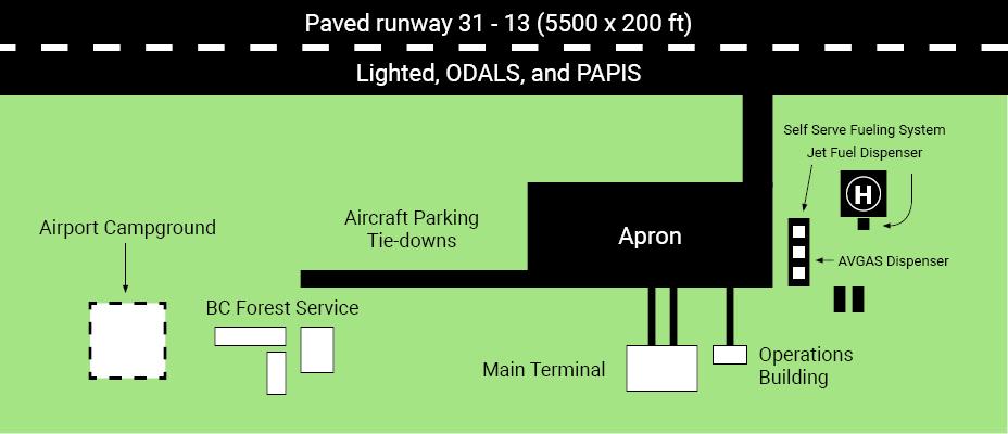
Services
FUEL: 100LL, JA-1 w/FS11, 24-hour self serve 250-992-2208 or
250-992-0171. VISA, Mastercard and private company accounts. Single point refuelling. Heli refuelling at pad.
S: 2,4,5,6, free campground, free showers, tie-downs, plug-ins,
wireless internet in main terminal.
Rwy data
Rwy 13(130º)/31(310º) 5501x200 asphalt
RCR: Opr CRFI, Win maint Nov 1 to Mar 31, 14-05Z Mon-Fri,
16-0030Z Sat, 16-05Z Sun except holidays, O/T 2 hr PNR, call out chg may be levied. PLR/PCN
PAD DATA: 50’ x 50’ concrete 70’ x 70’
LIGHTING: 13-AO (TE ME) P2, 31-AO (TE ME) P2 ARCAL-122.2 type K
Comm
RCO: Williams Lake rdo 122.2 (RAAS) 14-06Z‡
MF: Williams Lake rdo 14-06Z‡ O/T tfc 122.2 5NM 4800 ASL (CAR 602.98)
AWOS: 124.4
Nav
NDB: YQZ 359 (M) N52 57 38 W122 29 10 330º 3.6NM to A/D
Pro
Rgt hand circuits rwy 13 (CAR 602.96). Ngt circuit pro see VTPC.
Caution
Adj to and E of both apchs are hills marked by hazard bcns. 100’ AGL trees along W side of rwy 500’ from rwy edge. Only pilots familiar with local terrain should use this aprt dur hrs of darkness. Ngt ops not recommended unles all 3 hazard bcns are oprg. Extv smoke from pulp mills frequently obscures apch to rwy 31. Reported winds may not be representative of landing area winds